Coldwater Lake Watershed & Shoreline Assessment Project
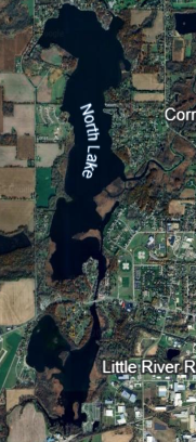
In Branch County there are two major lake chains. The Randall Chain sits immediately west of the City of Coldwater and includes Messenger → South → Randall → North → Cemetery → Craig → Morrison. South Lake in this chain is shallow and marsh-fringed, with limited existing development because of wet shoreline conditions. It receives flow from the Coldwater River and Sauk River (East Branch Coldwater River) and drains north through the chain. Michigan DNR
Climate, precipitation, snow & freeze timing (planning loads, access, and schedules)
- Typical precip & snow (local watershed): Long-term DNR/USDA figures for the Randall Chain watershed show about ~33 inches of annual precipitation and ~47 inches of annual snowfall. Expect wet shoulder seasons and saturated soils near the marsh margins. Michigan DNR
- NOAA normals (methodology/reference): Current U.S. climate normals use 1991–2020 30-year baselines; use these for design and scheduling assumptions. NCEI+1
- Freeze/frost window (regional planning): Midwestern freeze climatology tools (MRCC/USDA) show first 32°F freezes typically late Sep–Oct in south-central Michigan—useful for concrete/asphalt cure plans and landscaping. For exact dates by year, consult MRCC’s Freeze Date Tool. MRCC
Hydrology, levels & flooding
- Hydrologic setting: The Randall Chain formed in glacial outwash over Coldwater Shale; shorelines commonly have hydric muck soils (Houghton, Adrian, Edwards)—very poor bearing and seasonally saturated. Michigan DNR
- Shallow, marshy subsystem: Messenger + South Lakes together are ~172 acres, ~3 ft mean depth, with a ~2.3-day flushing rate—conditions that keep margins wet and sensitive to fill/disturbance. Development has historically been limited because of marshy shorelines. Michigan DNR
- Flow controls & legal levels: Lake levels in Branch County are maintained via court-established “legal lake levels” and operated by the Branch County Drain Commissioner (different basins have different setpoints). For Coldwater Lake (the big lake at the south end of the South Chain, not the Randall Chain), legal targets are 984.5 ft (summer) and 983.5 ft (winter)—useful context for how area lakes are managed. Contact the Drain Commissioner for the specific Randall Chain/South Lake legal levels and drawdown practices. COLDWATER LAKE ASSOCIATION+1
- USGS gauges: The Coldwater River near Coldwater/Hodunk has USGS stream gauges you can check for stage/flow when planning access and erosion controls. USGS Water Data+1
- Recent (2025) conditions: Local reporting (Sep 4, 2025) noted lower-than-target lake levels across parts of Branch County after a dry stretch—good reminder to verify current levels before finalizing elevations. The Daily Reporter
- Floodplains: Parcel-specific flood risk and Base Flood Elevations are on the FEMA Flood Map Service Center; pull the exact lot to see if any AO/AE zones clip the shoreline or access road. FEMA Flood Map Service Center
Wetlands & permits (Michigan-specific)
- What’s regulated: In Michigan, wetlands are regulated under Part 303 (Wetland Protection Act); activities in or near connected wetlands (including those within 500 ft of an inland lake/stream) generally require an EGLE permit. Many shoreline wetlands around South Lake will qualify. Michigan
- How to check & apply:
- Use the EGLE Wetlands Map Viewer to identify potential wetlands and hydric soils (screening only; delineation still needed). Michigan+1
- Apply through the EGLE/USACE Joint Permit Application for work such as fills, boardwalks, seawalls, dredging, culverts, or driveways across wetlands. Michigan
- Coordinate early with the Branch County Drain Commissioner (they run Soil Erosion & Sedimentation Control permits for earth disturbance ≥1 acre or within 500 ft of water). Branch County
- Technical basis: Hydric soil mapping (NRCS/EGLE) and the USACE Midwest Regional Supplement guide delineations; expect on-site wetland flags by a consultant. EGLE Maps & Data+1
Soils & geotech notes (buildability)
- Common shoreline soils: Houghton/Adrian/Edwards mucks and peat are widespread—low shear strength, high compressibility, seasonal water at/near grade; anticipate undercutting, surcharge, piles/helical piers, or geogrid for support, plus construction mats for access. Michigan DNR
- County soils reference: For parcel-scale bearing, depth to seasonal high water, and limitations for roads/septic, use USDA Web Soil Survey as a first pass; always verify with borings. Web Soil Survey
Lake facts (quick context)
- South Lake (Branch County): ~118 acres, ~18 ft max depth; adjacent communities include Coldwater and Quincy. (Field-verified details vary by source; treat as approximate and confirm with latest DNR bathy.) Lake-Link
- South Chain vs. Randall Chain: Don’t confuse the South Chain (Coldwater/Marble chain southeast of town) with the Randall Chain (where South Lake sits west of town). If your site is west of town near Messenger Lake/Memorial Park, you’re in the Randall Chain. Coldwater Country+1
Action checklist for a shoreline/wetland build here
- Confirm exact parcel & chain (Randall vs. South Chain) and pull FEMA FIRM for flood zones/BFE. FEMA Flood Map Service Center
- Wetland screening (EGLE Map Viewer) → professional wetland delineation during the growing season; flag limits and ordinary high-water mark. Michigan
- Soils & geotech: Web Soil Survey pre-screen → borings for foundation/subgrade options (muck/peat likely). Web Soil Survey
- Permitting path: EGLE/USACE Joint Permit Application (Part 303 wetlands; Part 301 inland lakes/streams if in the water), plus Soil Erosion & Sedimentation Control with the Drain Commissioner. Michigan+1
- Set elevations against current legal lake levels and seasonal variation; confirm with Drain Commissioner and nearby USGS gauges. COLDWATER LAKE ASSOCIATION+1
- Design choices for saturated margins: elevated boardwalk access, helical/pile foundations, permeable approaches, and shoreline protection designed to EGLE standards (soft-shore where feasible). Michigan